CALIFORNIA, Sept. 10 (Our California Times) — NOAA’s September forecast put the chance of El Niño reaching “Super El Niño” strength at 97% during the fall and winter, with the pattern expected to continue into early spring. For California, the main step now is to follow National Weather Service forecasts and local emergency alerts as winter approaches, especially from December through March.
The forecast does not call for a specific California disaster or issue a local flood warning. It describes a seasonal climate pattern that can change the odds of certain types of weather.
What is El Niño?
El Niño occurs when ocean water in the equatorial Pacific becomes warmer than usual. That extra heat changes the position and strength of the jet stream and other large-scale wind patterns around the world.
“Super El Niño” is a term used in the supplied forecasts for an unusually strong event. Those forecasts describe the benchmark as equatorial Pacific water temperatures at least 2 degrees Celsius above average for three consecutive months. The available reports do not establish that this threshold has already been met.
Forecast probabilities have risen over time. NOAA’s August outlook gave a 90% chance that the event would rank among the strongest on record during fall and winter, up from 81% in July. NOAA’s September outlook raised the chance of Super El Niño conditions to 97%. A separate report said NOAA gave a 75% chance of the event reaching historic strength between October and December 2026.
The percentages refer to different forecasts and definitions, so they should not be treated as competing measurements of the same thing. They indicate growing confidence that the event will be unusually strong, not certainty about every local weather outcome.
Why can El Niño quiet the Atlantic?
El Niño often increases upper-level winds over the Atlantic tropics. Those winds, also called wind shear, can tilt or tear apart developing tropical systems and make it harder for hurricanes to form or strengthen.
NOAA’s Climate Prediction Center said in a July 28 outlook that tropical-cyclone formation was unlikely over the Caribbean and central Atlantic “for the foreseeable future.” AccuWeather lead hurricane expert Alex DaSilva said, “The stronger El Niño becomes, the greater the likelihood of a less active end to the season.”
That pattern does not mean the Atlantic is risk-free. A single storm can still cause serious damage, and the available information does not provide a guarantee that no additional Atlantic hurricanes will form.
Why is the Pacific more active?
The same atmospheric pattern can favor tropical activity in the eastern and central Pacific. El Niño tends to place warmer water and weaker wind shear in those regions, providing more supportive conditions for tropical storms and hurricanes.
Weather.com reported that equatorial Pacific waters were 1.4 degrees Celsius above average on July 23, up from 0.7 degrees on June 11. It also reported that 23 of 26 forecast models supported a Super El Niño by the end of the year. Those observations were below the 2-degree benchmark described in the forecasts, but later outlooks assigned high odds to further strengthening.
What could California experience?
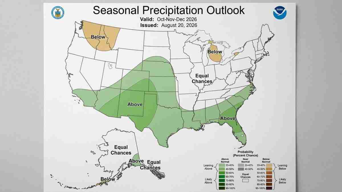
Southern California has a higher likelihood of above-average precipitation during a strong El Niño, according to reporting that cited Alexander Gershunov, a research meteorologist at Scripps Institution of Oceanography at UC San Diego. The most likely period for impacts was identified as December through March.
A stronger eastern Pacific storm pattern can also send large waves toward California’s coast. The pattern may raise the risk of coastal flooding by combining high waves with higher water levels, but no specific California coastal warning, wave height, flooding threshold or local impact forecast was identified in the available information.
These are seasonal tendencies, not guarantees. A strong El Niño does not mean every California location will be wet, and it does not determine the weather on a particular day.
What should residents watch?
Residents should rely on current National Weather Service forecasts, coastal statements and local emergency-management alerts when storms develop. Seasonal outlooks can help with planning, but they do not replace short-range warnings.
For coastal communities, that means paying attention to high-surf and coastal-flooding statements. Inland residents should monitor forecasts for heavy rain, flooding and travel impacts when individual storms are forecast. The available outlooks do not identify a specific California community or date that faces a confirmed threat.
The broader forecast message is clear: NOAA expects a very strong El Niño pattern to dominate the fall and winter, with the strongest potential California effects most likely from December through March. The exact weather will depend on the strength and position of individual storms as the season unfolds.