El Niño Could Ignite Eastern Pacific Hurricane Season in 2026, Raising Risks for California Coasts and Economy
El Niño is expected to raise Eastern Pacific hurricane activity in 2026 by warming sea surface temperatures and reducing wind shear, increasing the odds of more named storms, stronger hurricanes, and rapid intensification while suppressing Atlantic activity.
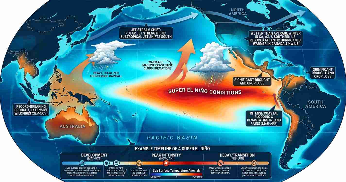
- El Niño odds and intensity: NOAA places ~61% chance of El Niño forming May–July 2026 with roughly a 25% chance of evolving into a super El Niño by fall.
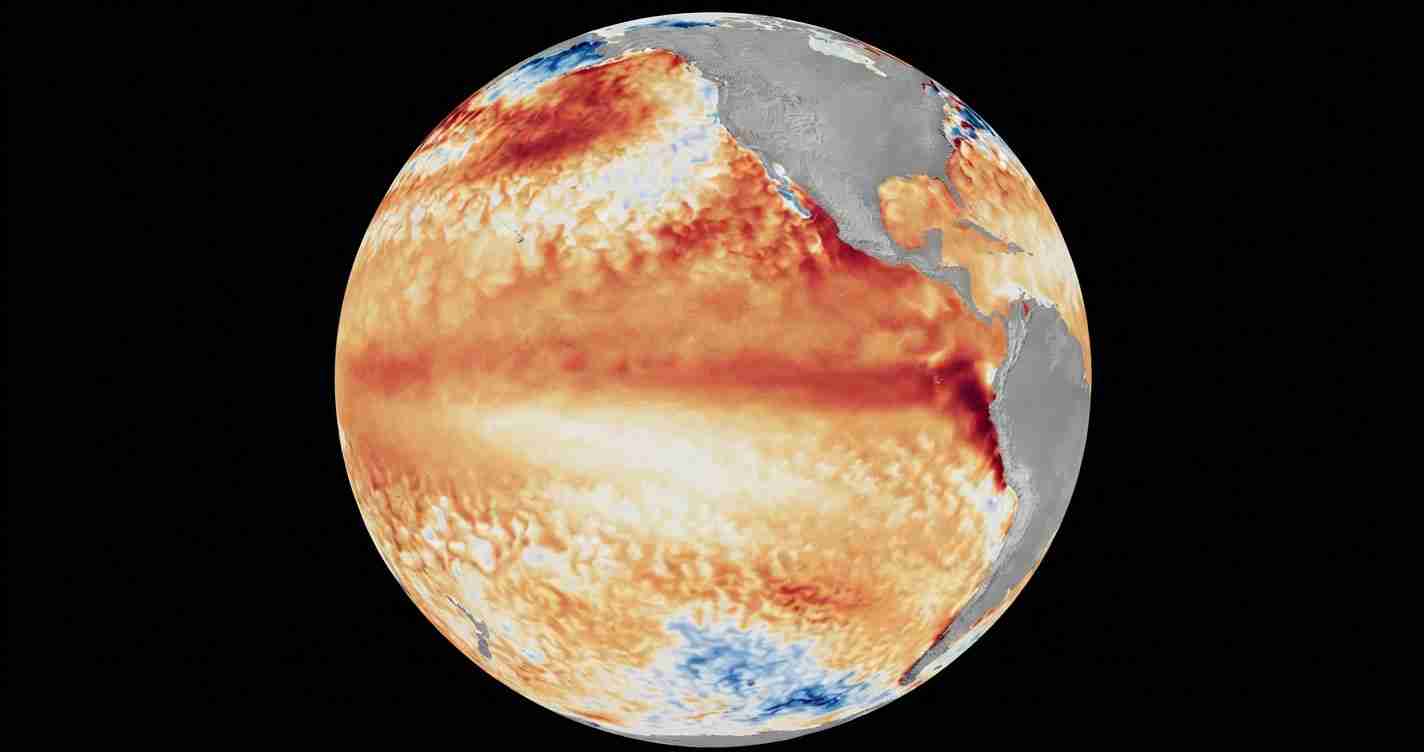
- Warm SSTs and ocean heat: Sea surface temperatures in parts of the Eastern Pacific are already ~1–3°C above average, increasing the risk of rapid intensification similar to Hurricane Otis (2023).
- Seasonal shift: El Niño typically favors a more active Eastern Pacific season (slightly above long-term averages) while suppressing Atlantic activity.
- California impacts: Even without direct hits, stronger Eastern Pacific storms can drive heavy rains, erosion, supply-chain disruption, and fiscal stress on infrastructure and emergency services.
What El Niño does in the Eastern Pacific
El Niño is a natural climate pattern that warms the central and eastern equatorial Pacific. That warming alters large-scale winds and rainfall patterns across the tropics. In the Atlantic, El Niño usually increases upper-level wind shear that inhibits storm development; in the Eastern Pacific it often does the opposite, reducing local shear and boosting convection so storms can organize and intensify more readily.
Warm ocean heat content is especially important. Observations and model guidance show parts of the Eastern Pacific with sea surface temperatures about 1–3°C above average and deeper warm layers, meaning storms have more energy available and a higher chance of rapid intensification.
“Warmer SSTs and reduced shear create an environment where storms can strengthen quickly — a dangerous dynamic forecasters are watching as 2026 approaches.”
Why it could ignite the 2026 season
- Early El Niño onset: If El Niño strengthens before mid-summer it can establish atmospheric patterns that favor more frequent and stronger storms during the July–October peak.
- Reduced wind shear: The Eastern Pacific often experiences lower upper-level shear during El Niño, allowing deeper convection and sustained organization.
- High ocean heat content: Deeper warm layers provide the fuel for rapid intensification, as highlighted by recent extreme intensification events such as Hurricane Otis in 2023.
Historical and statistical context
Since 1990, moderate or stronger El Niño years have tended to produce above-average Eastern Pacific seasons. One forecast cited an increase from the long-term Eastern Pacific averages (~15 named storms, 8 hurricanes, 4 major hurricanes) to roughly 17 named storms, 9 hurricanes, and 5 major hurricanes in El Niño years — a modest numeric rise that nonetheless increases the odds of severe landfall events for Mexico and indirect impacts farther north.
Timing matters
The calendar timing of El Niño’s development is critical. An early-developing El Niño (before mid-summer) typically favors a stronger Eastern Pacific season for the peak months. If El Niño forms late (after August), the Atlantic and Gulf may enjoy a longer window of average or above-average activity before Pacific conditions dominate. NOAA and ENSO-monitoring centers track these indicators because timing affects preparedness and resource allocation.
Forecast outlook from models and agencies
Multiple forecasting centers and climate models, including NOAA and research institutes, point toward a growing chance of El Niño in 2026 with some runs suggesting strengthening into the core hurricane months. Probabilities and model guidance are evolving; forecasters publish frequent updates as ocean and atmosphere observations arrive.
Relevant public analysis and reporting referenced in this briefing include coverage from Fox Weather, a summary from Time, and consolidated season statistics from Wikipedia. Technical briefings and panel discussions are also available in public video briefings cited below.
Implications for California
Economic and infrastructure risks
An active Eastern Pacific hurricane season raises risks to California’s economy even without frequent direct landfalls. Remnants and moisture feeds from Pacific hurricanes can produce intense rainfall, flash flooding, and landslides that disrupt ports, freight movement, and agriculture — all vital to the state economy. Local governments and port operators should review contingency plans and supply-chain resilience now to reduce potential economic losses.
Emergency services and fiscal preparedness
Moderate conservative policymakers typically emphasize cost-effective preparedness. County and state emergency managers should ensure evacuation routes, flood control systems, and shelters are ready. Pre-positioning supplies and coordinating with nonfederal partners can limit overtime and avoid expensive last-minute contracts. Insurers and local governments should reassess flood and stormwater management budgets proactively.
Water, drought and wildfire considerations
Pacific hurricanes can deliver much-needed precipitation to drought-stricken areas, but sudden heavy rain on burned slopes increases runoff and debris-flow risk. That creates competing priorities between water capture and protecting lives and infrastructure. Water agencies might consider temporary storage and controlled releases coordinated with emergency managers.
Coastal erosion and property exposure
Storm surge and large swell from closer-tracking storms can accelerate coastal erosion, damaging roads, seawalls, and properties. Planners should review building codes, insurance exposure, and targeted investments in shore protection and early-warning systems to minimize taxpayer and private losses.
Agriculture and fisheries
Heavy rain and strong winds threaten specialty crops and marine operations. Growers and fisheries are advised to consult forecasts and adjust harvest or deployment schedules to protect high-value assets; state agricultural agencies can support rapid-response measures.
Public information and personal preparedness
Clear, local messaging matters. Residents should update emergency kits, know evacuation zones, and verify insurance. Emphasize personal responsibility and community self-reliance: preparedness reduces public expenditures and eases emergency system strain.
Coordination with Mexico and federal agencies
Most damaging Eastern Pacific hurricanes make landfall in Mexico. California should include federal and Mexican counterparts in preparedness planning for humanitarian and logistic support if storms disrupt supply chains or generate cross-border impacts.
Resources and next steps for residents and officials
Residents should monitor NOAA and local National Weather Service updates and review county emergency plans. Officials should track ENSO updates from NOAA and modeling centers, prioritize levee and storm-drain maintenance, and ensure clear communication with schools, ports, and utilities.
Sources and further reading
- Fox Weather: “El Niño could boost hurricane activity in the Eastern Pacific in 2026”
- Time: “What to Know About a Possible Super El Niño in 2026”
- Wikipedia: 2026 Pacific hurricane season (summary and stats)
- Climate analysis video and briefing
- Additional expert discussion (video)
- ENSO and seasonal briefing (video)
(United States — Times Media Service)