Iceberg A-23A Disintegration: Reagan‑Era “Megaberg” Nears Final Breakup in the South Atlantic
Iceberg A-23A, once the world’s largest after calving from the Filchner‑Ronne Ice Shelf in 1986, is rapidly disintegrating in the South Atlantic, riddled with blue meltwater ponds as it drifts into warmer waters toward complete breakup.
Key takeaways
- Decades‑long story: A-23A calved in 1986 from the Filchner Ice Shelf and spent more than 30 years grounded before refloating and drifting north.
- Massive shrinkage: From roughly 4,000 km² originally to about 1,182 km² (≈456 sq mi) in early January 2026 per the U.S. National Ice Center.
- Imminent breakup: Satellite imagery shows extensive blue meltwater ponds and structural failure; scientists say the main berg may fragment fully within weeks to months.
- Scientific opportunity: The berg’s grounding, refloat, trapping in a Taylor column, and final melt provide a rare natural experiment for agencies including NASA Earth Observatory and the British Antarctic Survey.
Main content
Origins and long grounding
Iceberg A-23A is a tabular iceberg that calved from the Filchner–Ronne Ice Shelf in 1986. After calving it ran aground in the southern Weddell Sea and remained effectively stuck on the seabed for more than 30 years, becoming a long‑lived feature studied by researchers (NASA Earth Observatory; Wikipedia: A23a).
Break‑free and renewed travel
Around 2020 A-23A refloated and began to drift north. By late 2023 it had passed the Antarctic Peninsula’s northern tip; research ships such as the RRS Sir David Attenborough intercepted the berg to collect water samples and study its oceanic effects (British Antarctic Survey; Wikipedia: A23a).
Unusual ocean dynamics: the Taylor column
In early 2024 scientists observed A-23A trapped in a Taylor column — a rotating water column formed by seafloor features (notably near Pirie Bank). That trapping slowed the berg and caused it to spin, delaying its northward journey, a phenomenon documented by the British Antarctic Survey and summarized in public sources (Wikipedia: A23a).
Heading into the iceberg “graveyard”
Once freed from the Taylor column, A-23A resumed its drift toward the open Southern Ocean and the waters around South Georgia — an area long dubbed an “iceberg graveyard” where warm, rough seas rapidly melt large bergs. By January 2025 the berg was roughly 278 km (173 miles) from South Georgia and continued north (Wikipedia: A23a).
Size changes and last year’s breakups
Over decades A-23A fractured multiple times. It began near 4,000 km² (about 1,500+ sq mi) and, after major breakups during 2024–2025, the U.S. National Ice Center listed A23A at about 1,182 km² (≈456 sq mi) in January 2026 — still larger than New York City but a fraction of its original area (NASA Earth Observatory; U.S. National Ice Center; NOAA/NESDIS).
Meltwater ponds and structural failure
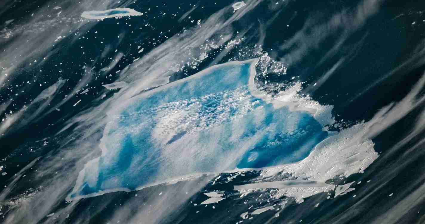
High‑resolution satellite imagery dated Dec. 26, 2025, shows A-23A riddled with blue meltwater ponds — surface pools that deepen the ice’s blue color. Ponded water increases stress on existing cracks and can trigger rapid fracturing. NASA images also show a rampart‑moat pattern at the waterline and a freshwater “blowout” where ponded water poured over an edge into the ocean, producing a visible plume (NASA Earth Observatory).
Why scientists are watching
Researchers describe A-23A as a rare natural experiment: its long grounding, later release, trapping in dynamic ocean features and final march into warm waters let teams observe iceberg–ocean interaction, nutrient changes and biological responses such as phytoplankton blooms. Agencies involved include NASA Earth Observatory, the British Antarctic Survey, and national agencies across Europe and the U.S.
“A-23A’s multi‑decade arc provides an uncommon window into how very large icebergs influence circulation and biology across vast ocean regions.”
Iceberg A-23A Disintegration: expected fate
Because A-23A is now moving into waters measured near 3°C and will encounter warmer conditions north of South Georgia, scientists quoted by NASA Earth Observatory expect the main berg to fragment fully within the austral summer — meaning weeks to months from late December 2025 — producing many smaller bergs and fragments that will melt away.
Implications for California
Economic impact
Direct effects on California are minimal: A-23A is far from West Coast shipping lanes. Still, the episode highlights the importance of sustained funding for satellite and ocean‑observation systems (data providers such as NOAA/NESDIS and NASA Earth Observatory) that support maritime safety, commerce and climate intelligence relied upon by California ports, insurers and exporters.
Political consequences
For a politically moderate conservative audience in California, A-23A’s breakup is a balanced talking point: an impressive natural story with scientific value but not a single, definitive policy signal. Policymakers may use the event to advocate targeted investments in marine research, satellite surveillance and port resilience — practical measures with fiscal and security benefits.
Social and community effects
California communities will not experience direct physical impacts from the berg’s demise. The event can serve as an educational tool for schools, museums and media to explain ocean processes, the role of federal research agencies and international cooperation in advancing science.
Practical applications for California residents and officials
- Maintain support for satellite and ocean‑observation funding that provides global maritime hazard warnings (NOAA/NESDIS).
- Use A-23A as a case study to inform workforce training in marine technology, remote sensing and data analysis.
- Coastal managers and insurers should continue to prioritize locally material risks (sea‑level rise, storms, port resilience) while integrating insights from global ocean dynamics.
Sources and tracking tools
Key reporting and tracking on A-23A come from: NASA Earth Observatory, the British Antarctic Survey, NOAA/NESDIS, the U.S. National Ice Center, and broader synthesis on the iceberg’s history (Wikipedia: A23a). An extended satellite case study is available from EUMETSAT.
Reporting note: Large public datasets and satellite images used in this report are maintained by NASA Earth Observatory, the British Antarctic Survey, NOAA/NESDIS and the U.S. National Ice Center. For an extended chronology and technical overview see Wikipedia: A23a and EUMETSAT’s case study.