Ancient Lake Manly Reappears in Death Valley’s Badwater Basin After Two Years of Unusual Storms
Following exceptionally heavy storms in 2023 and 2024, the ephemeral Lake Manly has reappeared in Death Valley’s Badwater Basin, transforming the salt flats into a temporary lake visible from space and briefly open for kayaking.
Key takeaways
- Lake Manly is the modern name for short‑lived shallow lakes on Badwater; the Pleistocene Lake Manly once filled the valley to hundreds of feet deep (see National Park Service and Outside magazine).
- Exceptional storms — Hurricane Hilary (Aug. 2023) and an atmospheric river (early 2024) — repeatedly filled Badwater, producing a lake roughly 6 miles by 3 miles and up to about 1 foot deep.
- NASA’s Earthdata satellite imagery confirmed substantial surface water on Dec. 10, 2025 (NASA Earthdata), and park managers halted boating to prevent surface damage.
What Lake Manly is
Lake Manly historically refers to a large pluvial lake that filled Death Valley during the last ice age. Today, rangers and scientists use the name informally for temporary, shallow lakes that form on the Badwater salt flats after heavy rains. These modern ponds are fleeting echoes of the Pleistocene lake but are visually striking against the usual white salt crust. For park guidance see the National Park Service and reporting by Outside magazine.
Where it forms: Badwater Basin
Badwater Basin sits about 282 feet below sea level and is North America’s lowest point. The basin is an endorheic bowl: water that reaches it has no outlet and leaves only by evaporation or infiltration. Under normal conditions the floor is a dry salt pan with polygonal crust; when runoff and rainfall exceed evaporation, surface water ponds and produces a temporary lake.
How 2023 and early 2024 refilled the basin
In August 2023, remnants of Hurricane Hilary delivered roughly 2.2 inches of rain to parts of Death Valley — an exceptional single‑storm total for the park — enough to flood the Badwater flats and create a modern Lake Manly several inches to about a foot deep in places. Water persisted for months, and a strong atmospheric river in February 2024 added about 1.5 inches of rain and expanded the lake again. Sustained winds from Feb. 29–Mar. 2 pushed water northward by roughly 2 miles, producing a “traveling lake” that spread shallower water over a wider area and accelerated evaporation. Sources: National Park Service; Outside magazine.
Satellite confirmation and timing
On Dec. 10, 2025, NASA Earthdata published a false‑color Harmonized Landsat–Sentinel‑2 image showing a conspicuous dark blue water body in Badwater Basin. The remote‑sensing confirmation demonstrates that repeated heavy precipitation since 2023 produced surface water detectable from space.
Hydrology: why the lake forms and why it’s usually short‑lived
Death Valley’s steep walls channel mountain runoff to the basin floor. With no outlet, pooled water only leaves by evaporation or infiltration. Extreme heat and aridity normally evaporate shallow pools in days to weeks, leaving polygonal salt crusts. Only when storms are unusually heavy or repeated does runoff overwhelm losses long enough to form a broad, shallow lake that slowly contracts as water is lost. Sources: National Park Service; Outside magazine.
How rare is this event?
The National Park Service notes temporary lakes occur “every few years” when rainfall is sufficient, but the 2023–2025 re‑formation was notable for depth, areal extent, multi‑month duration and multiple refilling storms. In the modern record, a multi‑month, multi‑refill lake large enough for boating is uncommon. Sources: National Park Service; Outside magazine.
Visitor experience, safety and management
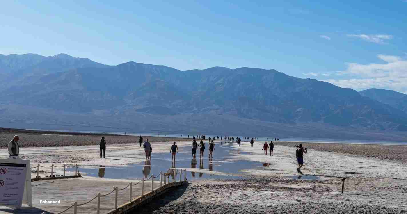
When present, Lake Manly can be a mirror‑like sheet of water reflecting the Panamint Range, with submerged salt polygons visible beneath clear water. That spectacle drew visitors and briefly allowed kayak and small‑boat activity. Park staff observed growing damage from people walking and dragging boats across soft mud and intact salt crust — deep footprints and drag scars that can persist for years. To protect the resource, park managers halted boating and now ask visitors to approach water only from compacted paths near the Badwater parking area.
“Footprints and boat drag marks can compromise the park’s fragile surface and last long after the water recedes,” park officials warned.
Climate context and scientific perspective
Scientists caution that single events should not be directly attributed to climate change without formal attribution studies. Still, a warmer atmosphere can hold more moisture, increasing potential for extreme rainfall. The sequence beginning with Hurricane Hilary and followed by atmospheric rivers fits a pattern of more intense short‑term precipitation in parts of the West. The modern Lake Manly remains tiny and short‑lived compared with the Pleistocene lake that filled the valley for thousands of years. Source: Outside magazine.
Implications for California
Economic impact: The reappearance briefly boosted tourism interest, producing modest, short‑term benefits for nearby businesses that serve park visitors, though boating closures and stricter access guidance can limit recreational revenue.
Political and management consequences: Land managers face pressure to communicate and enforce rules that protect both visitors and resources. For a politically moderate conservative audience, the event underscores the need for clear stewardship: enforce access limits, protect public assets, and ensure safe recreation while avoiding heavy‑handed restrictions. Park funding, visitor education and signage may become focal points.
Social and safety effects: Soft mud under shallow water can trap feet and vehicles; unprepared visitors increased risk and potential demand on emergency responders. Park guidance to stay on compacted paths and avoid soft mud protects people and resources.
Cultural and educational relevance: The transient return of Lake Manly is a teachable moment for schools, museums and public programs about Earth history, closed‑basin hydrology, and preservation of rare natural features.
Practical applications for residents and visitors
Californians and other visitors should check updates from the National Park Service before traveling. Bring plenty of water, stay on designated compacted surfaces near the Badwater parking area, heed closures and avoid entering soft mud or attempting to launch boats where prohibited. Park managers will continue to monitor conditions and adjust access rules to protect safety and the landscape.
Reporting and data sources
- National Park Service news release on Lake Manly and Badwater Basin
- Outside magazine reporting and analysis
- NASA Earthdata image archive and satellite confirmation
Note: This article preserves reported facts, timing and source links from the National Park Service, Outside magazine and NASA Earthdata as cited above.