Evacuation Warnings Reach San Bernardino County
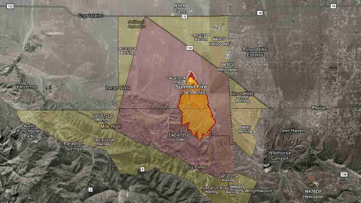
Pinon Hills, Calif. (Our California Times) – The Summit Fire burning in the Angeles National Forest has rapidly expanded to about 2,581 acres as of Friday, July 10, 2026, pushing new evacuation warnings into San Bernardino County communities that have seen major wildfire threats before, including Piñon Hills and Wrightwood.
Top areas covered:
-
Fire size, spread and firefighting response
-
Evacuation orders and warnings in Los Angeles and San Bernardino counties
-
Shelter and animal care options for displaced residents
-
Public health and smoke advisory information
-
Historical wildfire context for Angeles National Forest communities
Growing blaze in Angeles National Forest
The Summit Fire began just before 1 p.m. near Jesus Canyon Road and East Avenue Z in the Llano area of Los Angeles County and quickly grew from a small brush fire into a fast-moving wildfire. Within hours it expanded from 600 acres to more than 1,600 acres, eventually reaching an estimated 2,581 acres by Friday evening as steep terrain and limited access hampered ground crews. At least 10 air tankers have been deployed over the fire, with additional aerial resources requested to help slow its rapid rate of spread and protect threatened structures.
Firefighters are focusing heavily on structure defense in Piñon Hills as the fire continues to burn toward the San Bernardino County line, and Cal Fire and U.S. Forest Service officials are closely monitoring its movement into new fuel beds. The Summit Fire is burning in the already high fire-danger Angeles National Forest, which has seen partial closures and elevated restrictions in recent seasons due to repeated large fires and extreme conditions.
Evacuation orders in Los Angeles County
Mandatory evacuation orders remain in place for LAC‑E107, defined as north of Jubilee Road, south of Pearblossom Highway, east of Largo Vista Road and west of 263rd Street. In addition, residents in LAC‑E127‑C — north of Cardinal Road, south of Angeles Crest Highway, east of Timberline Drive and west of Cardinal Road — have been ordered to leave the area as firefighters work to keep the blaze away from homes and infrastructure.
Evacuation warnings, which signal a heightened threat and urge residents to prepare to leave quickly, have been issued for zones LAC‑E126‑A, LAC‑E127‑A, LAC‑E127‑B, LAC‑E128‑A and LAC‑E1340 in Los Angeles County. Residents in these warning areas are being urged to monitor official alerts and maps and to move pets, livestock, and valuables to safer locations before conditions potentially worsen.
Warnings now in Piñon Hills and Wrightwood
For San Bernardino County, evacuation warnings are now in effect for Piñon Hills and Wrightwood, including zones PIN005, PIN006 and WWD03. No formal evacuation orders have been issued inside San Bernardino County as of Friday, but sheriff and fire officials are strongly encouraging residents with pets or livestock to leave ahead of any rapid changes in fire behavior.
These communities are no strangers to wildfire threats: Piñon Hills and Wrightwood were placed under evacuation orders and warnings during the 2024 Bridge Fire, and Wrightwood faced similar alerts in earlier incidents such as the Bobcat Fire and other Angeles National Forest blazes. Past fires in the region have produced rapid, wind‑driven runs that forced full community evacuations and highlighted how quickly conditions can change along Highway 138, Lone Pine Canyon, and the Angeles Crest corridor.
Shelters and animal care
An evacuation shelter has been opened at the Antelope Valley Family YMCA, located at 43001 10th Street West in Lancaster, allowing small pets to stay with their owners. Residents seeking refuge there can call 661‑723‑9622 for information about capacity and available services.
For animal care, the Los Angeles County Animal Care Center at 38550 Sierra Highway in Palmdale is accepting small animals displaced by the Summit Fire. Owners can reach the center by calling 661‑575‑2888 or emailing palmdale@animalcare.lacounty.gov to coordinate intake and care for their pets. Past major fires, including the Bridge Fire, have shown the importance of early relocation for animals, with facilities in Victorville, Fontana, Devore, and Palmdale frequently used to receive pets and livestock from evacuation zones surrounding the Angeles National Forest.
Public health and smoke advisory
The South Coast Air Quality Management District has issued a smoke advisory for the South Coast Air Basin, in effect until 5 p.m. Saturday, due to the Summit Fire smoke plume. Current particle pollution levels are rated between Good and Moderate, but officials warn that conditions can deteriorate quickly if winds shift or fire activity intensifies.
AQMD advises residents in smoke‑impacted areas to remain indoors with windows and doors closed, avoid strenuous outdoor activity, and use air conditioning or air purifiers on recirculation mode when possible. Sensitive groups — including children, older adults, and people with heart or lung disease — are urged to take extra precautions, noting that Southern California has repeatedly seen smoke‑driven air quality advisories tied to wildfires in the Angeles National Forest and nearby foothill communities.
History of wildfire pressure on mountain communities
Mountain and high‑desert communities along the Angeles National Forest edge have endured a series of significant wildfires over the past decade, including the 2020 Bobcat Fire and subsequent incidents that forced closures across tens of thousands of acres of forest land. Portions of the forest along Angeles Crest Highway only reopened after extended closures prompted by severe burn scars and post‑fire hazards, underscoring ongoing vulnerability in this rugged terrain.
The 2024 Bridge Fire and earlier events brought evacuation orders to Piñon Hills, Wrightwood, Paradise Springs, and East Fork communities, while lifting and re‑issuing warnings as fire behavior shifted. These repeated emergencies have driven stricter fire‑danger ratings and elevated restrictions, including Stage 2 fire rules in similar Western forest jurisdictions, and serve as a reminder that residents in these areas must stay prepared for fast‑moving incidents like the Summit Fire.
Maps, alerts and preparedness
Residents in all affected zones are being directed to consult official evacuation maps at protect.genasys.com and to follow local emergency alerts from county sheriff and fire agencies. Officials emphasize that evacuation warnings can become orders with little advance notice when wind, fuel and topography combine to accelerate fire spread.
Conservative local leaders in high‑fire‑risk communities have long argued for stronger forest management, expanded fuel‑reduction projects, and increased aerial firefighting capacity to protect families, property rights and critical infrastructure along the Angeles National Forest boundary. The Summit Fire’s rapid growth near Llano, Piñon Hills and Wrightwood is likely to intensify ongoing debates over how California allocates resources for wildfire prevention, forest access, and emergency preparedness in rural and exurban communities.