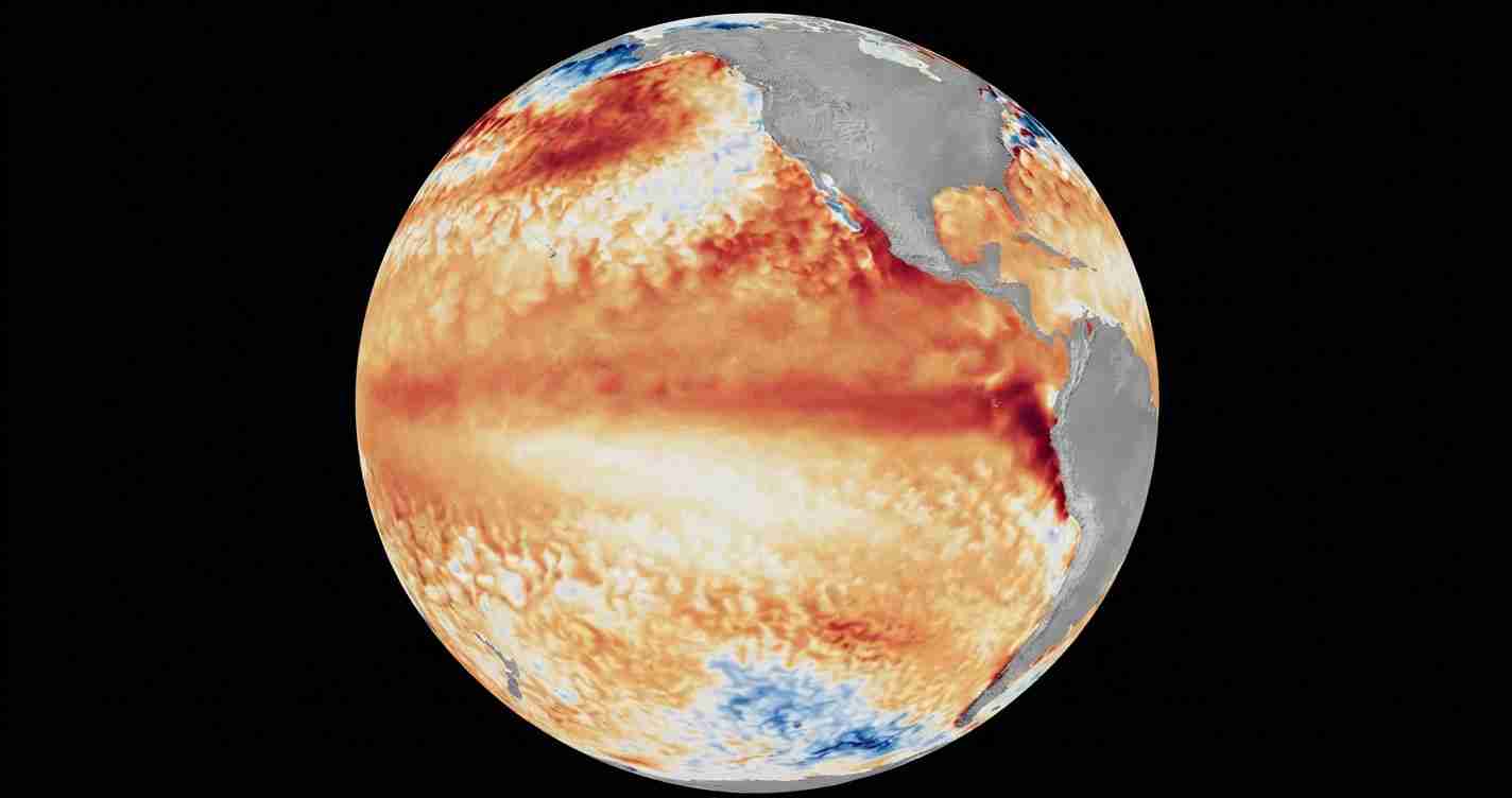
WASHINGTON, July 7 (San Diego News Online) — Check local winter and flood outlooks now: NOAA’s Climate Prediction Center says El Niño conditions are already present in the tropical Pacific and are expected to strengthen through the Northern Hemisphere winter of 2026-27.
The federal forecast office put its ENSO Alert System at “El Niño Advisory” on June 11. ENSO stands for El Niño-Southern Oscillation, the climate cycle that includes El Niño, La Niña and neutral conditions in the tropical Pacific.
What NOAA is seeing now
NOAA said above-average sea-surface temperatures developed first in the far eastern equatorial Pacific in early February, then spread across the central and eastern equatorial Pacific by mid-April.
In its June advisory, the Climate Prediction Center said the latest weekly Niño-3.4 index was +0.7°C. That index is one of the main ways forecasters track whether the central Pacific is warming enough to support El Niño conditions. NOAA also reported Niño-4 at +0.7°C and Niño-1+2 at +2.1°C.
Those numbers matter because El Niño is not just a label. It describes a broad pattern of warmer-than-average water in the tropical Pacific, along with the changing winds and atmosphere that go with it.
What El Niño means in simple terms
In NOAA’s basic ENSO explainer, El Niño is the warm phase of the cycle. La Niña is the cool phase. Neutral is the in-between state.
When El Niño develops, it can nudge weather patterns far from the Pacific. The effects are not the same everywhere, and they do not guarantee one set outcome for a city or state. But seasonal forecasters watch it closely because it can change the odds for rain, snow, temperature and flooding.
How strong could this one get?
NOAA said its North American Multi-Model Ensemble, which includes the NCEP CFSv2 model, points to further strengthening into winter.
The Climate Prediction Center said there is a 63% chance of a very strong El Niño during November-January. NOAA said an event that strong could rank among the largest in the historical record going back to 1950.
That does not mean the forecast is locked in. It does mean the odds have shifted enough for NOAA to issue an advisory rather than wait for more warming.
Why readers should pay attention
For most people, El Niño is not a storm warning by itself. It is a seasonal heads-up.
NOAA’s Ocean Service says an El Niño can raise the risk of high tide flooding in some U.S. locations. That is one reason coastal communities and local emergency managers watch seasonal NOAA updates closely.
The pattern can also shape winter planning in places that depend on snow, rain or milder cold. Because the effects vary by region, the most useful next step is to follow local forecasts and NOAA seasonal outlooks as the year goes on.
For Washington-area readers, the main takeaway is simple: NOAA says the tropical Pacific is already in El Niño, and forecasters expect it to build through winter 2026-27. The exact local impacts will depend on where you live and how the broader atmosphere responds in the months ahead.